


SANTORINI OIA COLORS modern impressionist impasto palette knife oil painting by ANA MARIA EDULESCU
by Ana Maria Edulescu


Original - Sold
Price
Not Specified
Dimensions
70.000 x 50.000 x 2.500 cm.
This piece has been already sold. Please feel free to contact the artist directly regarding this or other pieces.
Click here to contact the artist.
Title
SANTORINI OIA COLORS modern impressionist impasto palette knife oil painting by ANA MARIA EDULESCU
Artist
Ana Maria Edulescu
Medium
Painting - Oil On Canvas
Description
ORIGINAL IMPASTO PALETTE KNIFE OIL PAINTING ON STRETCHED CANVAS, SIZES : WIDTH - 28 INCHES, HEIGHT - 20 INCHES, DEPTH - 1 INCH
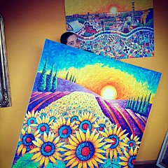
''SANTORINI OIA COLORS'' is a modern impressionist impasto palette knife oil painting by ANA MARIA EDULESCU.
I was inspired to paint this work by the beauty of Santorini island. I am in love with the Santorinian village named Oia with it's bright white houses, it's blue churches' domes and the stunning deep blue of the Aegean sea. This is my favorite spot from Oia with colorful and white houses, a beautiful church, all seen on the background of that amazing blue sea. In foreground I painted in an abstract manner - with bold palette knife strokes - luxurious pink bougainvillea flowers.
First time I visited the Greek island Santorini in 2010 and this summer, after 7 years, I was again there to let my soul and eyes get inspiration of the amazing beauty of this place.
Santorini (Greek: Σαντορίνη, pronounced [sadoˈrini]), classically Thera (pron.: /ˈθɪrə/), and officially Thira (Greek: Θήρα [ˈθira]), is an island in the southern Aegean Sea, about 200 km (120 mi) southeast from Greece's mainland. It is the largest island of a small, circular archipelago which bears the same name and is the remnant of a volcanic caldera. It forms the southernmost member of the Cyclades group of islands, with an area of approximately 73 km2 (28 sq mi) and a 2011 census population of 15,550. The municipality of Santorini comprises the inhabited islands of Santorini and Therasia and the uninhabited islands of Nea Kameni, Palaia Kameni, Aspronisi, and Christiana. The total land area is 90.623 km2 (34.990 sq mi). Santorini is part of the Thira regional unit.[2]
Santorini is essentially what remains after an enormous volcanic explosion that destroyed the earliest settlements on a formerly single island, and created the current geological caldera. A giant central, rectangular lagoon, which measures about 12 by 7 km (7.5 by 4.3 mi), is surrounded by 300 m (980 ft) high, steep cliffs on three sides. The main island slopes downward to the Aegean Sea. On the fourth side, the lagoon is separated from the sea by another much smaller island called Therasia; the lagoon is connected to the sea in two places, in the northwest and southwest. The caldera being 400m deep makes it possible for all but the largest ships to anchor anywhere in the protected bay; there is also a newly built marina in Vlychada on the southwestern coast. The principal port is called Athinias. The capital, Fira, clings to the top of the cliff looking down on the lagoon. The volcanic rocks present from the prior eruptions feature olivine and have a small presence of hornblende.[3]
It is the most active volcanic centre in the South Aegean Volcanic Arc, though what remains today is chiefly a water-filled caldera. The volcanic arc is approximately 500 km (310 mi) long and 20 to 40 km (12 to 25 mi) wide. The region first became volcanically active around 3�4 million years ago, though volcanism on Thera began around 2 million years ago with the extrusion of dacitic lavas from vents around the Akrotiri.
The island is the site of one of the largest volcanic eruptions in recorded history: the Minoan eruption (sometimes called the Thera eruption), which occurred some 3600 years ago at the height of the Minoan civilization. The eruption left a large caldera surrounded by volcanic ash deposits hundreds of metres deep and may have led indirectly to the collapse of the Minoan civilization on the island of Crete, 110 km (68 mi) to the south, through a gigantic tsunami. Another popular theory holds that the Thera eruption is the source of the legend of Atlantis.
Santorini was named by the Latin Empire in the thirteenth century, and is a reference to Saint Irene.
Oia (Greek: Οία, pronounced [ˈi.a]) is a former community on the islands of Thira (Santorini) and Therasia, in the Cyclades, Greece. Since the 2011 local government reform it is part of the municipality Santorini, of which it is a municipal unit.[2] It covers the whole island Therasia and the northwesternmost part of Santorini, which it shares with the municipal unit of Santorini. The population was 1,230 inhabitants at the 2001 census, and the land area is 19.449 km2. The population and land area are distributed as follows: 962 persons on 10.150 km2 in Santorini, and 268 persons on 9.299 km2 in Therasia.
Along the cliff of Oia, houses have been delved into the porous volcanic rock (left over from a large volcanic explosion many years ago that sunk the center of the island). Parts of these houses are visible and the scenery that results from it is generally perceived as being typically Greek. The town is noted for its picturesque architecture, unique for its blend of relatively large (for the town's space) medieval Venetian houses (dubbed "kapetanea" gr: "καπετανέα" - as they belonged to the captains) with small incave village homes, called "yposkafa" (gr: "υπόσκαφα", caved-in) which were the housing form of the rest of the town's population. This is a reminiscent of the age of Venetian rule over the island. Other attributes of this era are the large Catholic population as well as the medieval fortifications to protect from pirates. To this day laws protect the natural and architectural beauty of the town from modern manifestations, such as public electrical wires.
In the evening hordes of people arrive simply to watch its sunset. Every available seat, wall, step or patch of ground is occupied and picnicking while watching the sunset is almost de rigueur.
A common method for enjoying the sunset is to take one of the boat charters from the docks at Thira. After visiting the volcano in the middle of the caldera, the boat will visit the opposite island for a time before heading out a mile or so from the island. At sunset the boat will sail in a figure 8 until the sun goes below the horizon, providing a long view of the setting sun and ample photographic opportunities. ( Wikipedia )
Uploaded
August 24th, 2017
Embed
Share
Similar Images


Comments (89)


Christopher James
One of your peers nominated this image in the 1000 views Groups nominated images by your fellow artist in the Special Features #14 promotion discussion. Please visit and pass on the love to another artist.....L/F/Tw

Mary Machare
Beautiful composition of this lovely place. I like how you surrounded the town scene with flowers. LF


Christopher James
Congratulation.....your wonderful work has been featured in the 1000 Views on 1 Image Group l/f/p


Luther Fine Art
Congratulations! Your marvelous art has been featured on the Home Page of the ABC Group. This art has been selected from the ABC Group's Z IS FOR ZEE (Zee is Dutch for sea)! You are invited to add this wonderful art to the features archive,

Madalena Lobao-Tello
CONGRATULATIONS!! Featured on Obsessed with Frida Kahlo. Great artwork with wonderful colors! F


Sherri's Of Palm Springs
Dear Ana, so beautiful as you are a friend. The colors are just wonderful.. I love the way you did the water and all the little extras that are so pretty Happy New Dear Ana... God Bless you always.. Sherri lf-G+ FB


Recently Viewed
